The St. Clair Region Conservation Authority (SCRCA) has issued a flood outlook with multiple rounds of rain and thunderstorms expected until Thursday.
Interim Flood Forecasting and Warning Coordinator Andrew McIntyre said Environment and Climate Change Canada (ECCC) and the Surface Water Monitoring Centre (SWMC) are forecasting rainfall amounts of 40 to 70 millimetres, with another 60 mm possible in thunderstorm activity.
"Total rainfall amounts are highly uncertain at this point, especially for rain brought on by thunderstorms," McIntyre said in a watershed conditions statement. "Thunderstorms are highly unpredictable and can hit some areas harder than others, resulting in higher local rainfall amounts. High amounts of rain in a short period of time may lead to flash flooding and pooling on roads, especially in more urban areas."
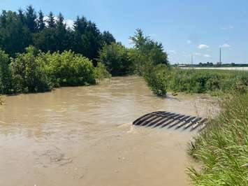
McIntyre added that the ground is already saturated and has low ability to soak up water.
"Rain will quickly run off into local watercourses," he said. "Smaller watercourses may overflow into low-lying areas that usually flood in the spring. Watercourses remain slightly elevated from the previous high water event last week. SCRCA expects water levels to rise quickly if the higher end of the forecast comes true."
Municipal staff are asked to monitor local conditions, and pay special attention to known local drainage problem areas.
Individuals are reminded to avoid watercourses and flooded areas due to dangerous conditions, slippery banks and cold, swift-moving water. Children and pets should be kept away from the water.
McIntyre said the notice will remain in effect until Monday, April 20 at noon, unless otherwise updated.