Strong winds and high lake levels have prompted conservation officials to issue a flood warning for Leamington.
The warning was issued Sunday afternoon and is in effect for Point Pelee Drive. The Essex Region Conversation Authority (ERCA), is asking people to avoid a few areas and obey posted signage by the road authority. The list of most affected areas include:
- Point Pelee Drive (County Road 33) between Sturgeon Creek Bridge and Point Pelee National Park. Water has overtopped the roadway.
- Robson Road between Cherokee Lane and the roundabout at Monarch Lane. Low portions of the roadway have taken on water as a result of waves overtopping breakwalls.
- West Shore Road between the ferry ramp and East West Road on Pelee Island.
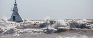
Provincial police had previously tweeted a picture of road conditions in the area.High winds and rising waters are making driving treacherous in the Point Pelee, Robson Road @TweetLeamington area. Point Pelee Drive has been closed, please avoid these areas where possible until water levels subside. ^jr. pic.twitter.com/fb3smRSssn
— OPP West Region (@OPP_WR) March 29, 2020
"There is currently a significant amount of splashing and spray with many breakwalls being overtopped," ERCA officials stated in a press release. "The splashing and spray and wave overtopping has flooded portions of Point Pelee Drive."
The remainder of the Lake Erie shoreline including the west and south shorelines of Pelee Island remains under a flood watch, with winds forecasted to remain strong throughout Sunday and into Monday.
The flood warning is in effect until Monday evening.