Heavy rain and snow melt has prompted a flood outlook by the St. Clair Region Conservation Authority (SCRCA).
It said winter storms over the past week brought varying amounts of snowfall across the region, with snowpacks measuring snow-water equivalents (SWE) of 10 to 35 millimetres.
The conservation authority said a warm front tracking into southern Ontario is set to dump five to 15 millimetres of rain, with above freezing temperatures continuing into Wednesday.
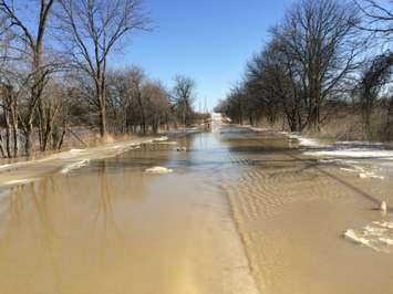
Ponding in low-lying areas is likely as soils become saturated.
The increased runoff and elevated water levels may lead to minor flooding into natural floodplain areas.
We're reminded to avoid watercourses and flooded areas because of dangerous conditions, slippery banks and cold swift moving water.
The flood outlook will remain in effect until noon on Wednesday, December 11, unless otherwise updated.
The St. Clair Region Conservation Authority includes the Sydenham River watershed and smaller watersheds draining directly into southern Lake Huron, the St. Clair River and northeastern Lake St. Clair.