Residents and businesses with waterfront property along the Thames River in Chatham-Kent can expect a soggy start to the weekend.
Officials with the Lower Thames Valley Conservation Authority (LTVCA) have released an updated forecast for local waterways, which includes expectations of some flooding in low-lying areas from Delaware down to Chatham.
The water in local ditches, creeks, and streams is expected to reach the top of the banks and possibly spill out a bit into floodplain areas with rain and thunderstorms expected to drop up to 20 millimetres of rain on the region Thursday with another five millimetres possible again Friday.
The waterways will also be filling up with some snowpack that is still melting further up the river in the London area.
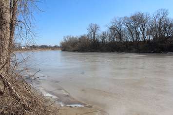
The sidewalk in downtown Chatham is expected to be flooded again, but the water levels on the river are not expected to be as high as they were during February's flooding that prompted a localized state of emergency. That event was brought on by an ice jam downstream and LTVCA officials said that is no longer a concern because all of the ice on the river has melted.
The water levels in the Chatham-Kent portion of the Thames River watershed are expected to start rising Thursday and remain high throughout the weekend.
LTVCA officials are once again reminding local residents to take extra caution to avoid the river, ditches, and streams because "the combination of slippery banks and fast moving cold water can be dangerous."