The environmental assessment to realign Talbot Trail away from Lake Erie and reopen the section of road between Coatsworth Road and Stevenson Road has been completed.
Talbot Trail has been closed since July 2019 because of shoreline erosion and road failure due to the unstable bluff slope in the area.
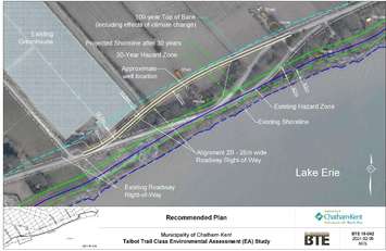
The municipality announced Wednesday that the interim solution will remove Talbot Trail from the 30-year hazard zone and allow the road to reopen until a previously approved long-term protection plan is implemented.
Chatham-Kent Council approved the short-term reopening plan at its meeting on February 26, 2024, including a new realigned right-of-way and two-lane arterial road to the northwest of its current position between Coatsworth Road and 3089 Talbot Trail following 2nd Concession Line at a cost of $4 million.
The long-term solution is to build a new road from Ellerbeck Road to Stevenson Road, along the existing 2nd Concession Line, which requires significant property acquisition, road improvements, and utility relocations, according to the municipality.
Chatham-Kent Manager of Engineering Mark McFadden previously told council that the realignment will have less impact on properties and will protect Talbot Trail from erosion for a minimum of 30 years.
The report noted the road realignment will mean acquiring land from 2961 and 3021 Talbot Trail. According to the municipality, both property owners "generally supported" the preferred alternative and would be open to discussing land acquisition.
Staff said they received some concerns from the public asking why the realignment of the existing roadway to reinstate traffic through this area is moving forward, as opposed to proceeding with the Long-Range Protection Plan corridor improvements and specifically improvements along 2nd Concession.
The municipality replied that the road is expected to last another 30 years and at that time it would either need maintenance, replacement, or relocation.
Some members of the public were also concerned about what climate change would do to the projected erosion rates and hazard zones. Administration said a 1m/year retreat rate is predicted over the next 30 years to reflect the expected acceleration due to climate change.
"As the 1m/year estimated erosion rate is only a prediction based on historical data, the location of the proposed relocated segment of the road has been conservatively set back from the projected future hazard zone," the report explained.
The environmental assessment report also acknowledged that the relocation of Talbot Trail will have minor impacts on the existing woodlot; however, they can be offset by re-naturalizing the area to the south, including the existing right-of-way.
No impacts to sediment transport in Lake Erie and no impacts to fish habitats in Lake Erie were also key highlights noted in the report.
Municipal officials also said no at-risk species were found within a one-kilometre square grid of the study area, but species-specific field investigations will be carried out during the appropriate seasons and under appropriate conditions before construction starts.
The municipality said a Stage 1 Archeological Assessment was conducted for the original Talbot Trail realignment because it has archeological potential due to the proximity of 19th-century transportation routes, settlement areas and structures, registered archeological sites, and ancient and current watercourses and wetlands, adding a Stage 2 Archaeological Assessment will be conducted as part of the detailed design.
"Talbot Trail was a historic travel route created in 1792 and was an important link in the early settlement of the area. The Technically Preferred Alternative maintains the heritage elements, including this historic route as well as the existing buildings. A small portion of farmland will be lost; however, the overall impact of this loss is insignificant," the report stated.
The environmental report will be available for public review from July 3, 2024 to August 2, 2024 and can be viewed by clicking here.
The municipality will proceed with land acquisition, detailed design, and supporting studies following the 30-days of public review.
The municipality said tendering and construction of the recommended improvements are planned for 2025.